Our boating season is drawing to a close and we are now on the Middle Levels. It's going to take a couple of posts to bring us up to date so this one tells of our travels up the last of the three Great Ouse tributaries - the River Wissey - and our cruise down the Relief Channel. So here goes:
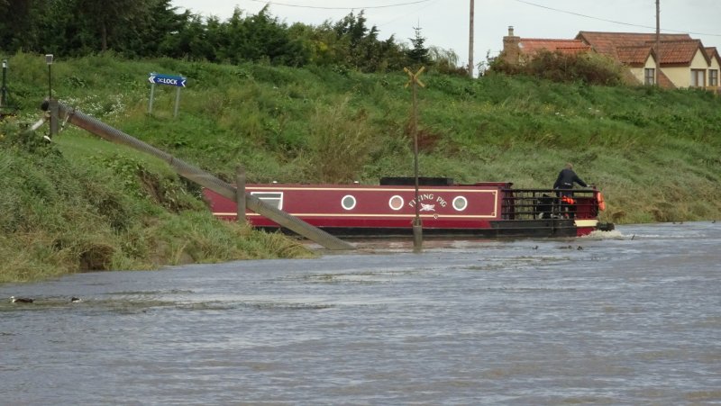
The confluence of the Wissey and the Ouse is only a mile or so upstream of Denver Sluice and we turned there last Wednesday off the huge wide River Ouse onto the tiny narrow Wissey.
 |
| This picture of the Wissey was taken soon after we turned onto it and gives a good idea of the scenery - tree lined and narrow but pretty deep so no difficulty navigating this river. |
 |
| About half way up the Wissey the wild natural scenery dramatically changes at Wissington where a huge factory converts sugar beet into sugar. The river flows round two sides of the factory. This factory is such a landmark that we had already spotted it from the River Little Ouse. |
 |
| Round the back of the factory several trees have come down making it difficult to pilot a narrowboat around the fallen branches. We have reported this to the Environment Agency so hopefully they will remove the trees from the river. |
 |
| Beyond the factory the river crosses two large lakes which appear to be deep enough to navigate anywhere from side to side. |
 |
| Like the Little Ouse, the Wissey crosses the Cut Off Channel on an aqueduct. Excess water in the Cut Off Channel can be sent north out to sea or south to reservoirs in Essex. Clever stuff. |
 |
| Here's a view from the aqueduct looking north down the Cut Off Channel. |
 |
| We are now coming through Stoke Ferry which is close to the navigable limit of the Wissey, some ten miles from the Ouse. |
 |
| The mooring at Whittington is free to GOBA members, which we are now. The mooring adjoins a caravan site which was handy for emptying the elsan. A board of rules greets visiting boaters which is a bit offputting, but the lady at the site was very friendly. One of the rules is 'no children'. |
 |
| In the afternoon we walked into Stoke Ferry which has a lot of historic buildings but now looks a bit forlorn with many in disrepair. It does have a shop but the pub closed earlier this year. Both churches have been closed. |
On Thursday we went back down the Wissey to Hilgay which is only a couple of miles from the Ouse.
 |
| But first we had to go another half a mile upstream to reach the point where you can turn round. This blue narrowboat had passed us half an hour before we set off and we met it broadside across the river. It was being taken out of the water on a trolley pulled up a ramp by an enormous old army lorry. |
 |
| When the lorry revved up to pull the boat up the ramp there was a huge cloud of exhaust but peering through the smoke we could just see the boat moving towards the ramp. |
 |
| It was touch and go for a while as the boat went up and then slid down the ramp, but eventually the tow worked and the boat went up leaving the river free for us. |
 |
| Here's the view looking up the ramp with the boat on the trailer at the top. |
 |
| Past the red narrowboat the river forks with a prominent drain to the left. This is the point where boats have to turn as the river is not navigable further up. The turn was not too difficult and even a full sized boat can turn here. |
 |
| Here we are on our way back crossing the first of the two lakes near the sugar factory. |
 |
| Here is rather a surreal photo Helen took looking through the girders of a bridge to the sugar factory. |
 |
| Thursday was a sunnier day for travelling downstream and here we are approaching Hilgay where there are ample moorings on a meadow before the road bridge. |
 |
| There is only one shop in Hilgay which is a butcher but it also sells fruit and vegetables, groceries and newspapers and we bought a wonderful pork pie, made on the premises. The photo is of the long avenue of lime trees leading to the church. |
-
 |
| Ian liked this fine carving on a gravestone in the churchyard. It was dated 1891 but the carving looks as sharp as if it was done yesterday. |
 |
| The Cut Off Channel runs parallel and close to the Wissey at this point so Ian walked up to have a look while Helen filled Leo's water tank. It looks like a navigable waterway but this is not allowed and there is no navigable connection. |
On Friday we returned to the Great Ouse but had one more adventure before going through the lock at Denver Sluice onto the tideway.
 |
| We've been trying for ages to get a decent picture of a Great Crested Grebe but every time you point a camera at one, they dive out of sight. But this one stayed long enough to have its photo taken. |
 |
| Here we are coming down the Ouse towards the Denver Complex. To the left are the sluices and the lock that connect with the tidal River Ouse. Straight ahead are the sluices that allow excess water from the Ouse into the Relief Channel that runs parallel to the tidal river to the outskirts of Kings Lynn. And to make matters more confusing the Cut Off Channel as a sluice (not visible in the picture) which connects it to the Relief Channel. It's all very complicated but basically excess water can be sent to Essex or out to sea by two routes. The main aim is to prevent the Fens being flooded. As for us we cruised up the right hand channel where a lock gives access to the Relief Channel. | | |
|
|
 |
| Helen is setting the lock for Leo. It's all electric, both the paddles and the gates. |
 |
| The lock takes boats down about 8 feet and out onto the Relief Channel. |
 |
| This view is looking back, having come out of the lock which is to the right beyond the lock landing. The sluices straight ahead connect the Cut Off Channel beyond to the Relief Channel. |
 |
| These Egyptian Geese were on the concrete by the sluices. |
 |
| If you think the Great Ouse is a wide river, you should try the Relief Channel! When we eventually turned round about 8 miles downstream there was no need for a three point turn. |
 |
| The Relief Channel is also very straight. You can see a bridge in the distance but it might be two miles away. However we were travelling at more than 5 miles an hour which is pretty fast for a narrowboat. We don't know how deep it is: perhaps it is bottomless. |
 |
| Although there is no navigation obstacle preventing you cruising to the edge of Kings Lynn, where the Channel ends in a sluice onto the tidal river, the last few miles are the province of a water ski club and other boats are not welcome. So here at Wigginhall Bridge we were obliged to turn round. |
 |
| This sign at the bridge makes clear that it is 'no entry' and 'turn round'. |
 |
| There are three new floating mooring pontoons on the Relief Channel and we stopped at the one at Wigginhall, St Mary Magdalen for lunch. We walked up to the church which was huge for such a tiny village and there is also a pub here - the Cock Inn - which does food. |
 |
| We moved back after lunch to the middle mooring at Stow Bridge which is right by the Heron pub which had been recommended to us by other boaters. This view from the road bridge shows Leo on the pontoon by the pub. We did not meet many boats down here, though we were surprised and pleased to see Leaside Lass, a boat that we had last seen in Bedford. We stopped for a chat with owners Esme and Brian as they were heading back to Denver that day. We also saw Fulbourne, the working boat last seen on the Lark and previously at St Neots. |
 |
| I mentioned that the tidal channel runs parallel to the Relief Channel so we walked across to it from the Heron. The tide was going out. Somewhere in the distance is Kings Lynn and the sea. |
The Heron was as good as we had been told with lovely food and good beer at reasonable prices. We enjoyed our evening meal there and it was but a short step back to the boat afterwards.
On Saturday we came back up the Relief Channel stopping for a few hours at the third mooring pontoon which is within 10 minutes walk of Downham Market. As well as some fine buildings, a hill (!!) up to the church and a market we also looked in at the Downham Discovery Centre. This is a museum, staffed by volunteers, in the old fire station and is well worth a visit. Did you know about the Downham Market Riot in 1816?
Once back up the lock we moored at Denver ready for our passage through the lock onto the tidal River Ouse on Sunday. But more about that in our next posting.