Tuesday, 25 June 2024

Peak Forest Canal

 This posting covers our experience on the Peak Forest Canal. This runs from Bugsworth and Whaley Bridge to Dukinfield Junction where it meets both the Ashton and the Huddersfield Narrow Canals. In the middle lie the Marple Locks, a flight of 16 leading down to the valley of the River Goyt. The Peak Forest has some spectacular scenery and its upper section lies part way up the side of the Goyt valley with views towards Kinder Scout and the other hills of the Peak District.

So here is the account of our journey on this canal. At Marple Junction where the Macclesfield meets the Peak Forest we turned right for 7 miles to the terminus at Bugsworth Basin. We then turned round and retraced our steps to reach the Marple Locks and beyond.

In the 7 miles between Marple and Bugsworth there are four lift or swing bridges, only one of which is power assisted. This one is Turf Lea Lift Bridge which is Helen powered by turning a windlass umpteen times to lift the bridge.

And this is Higgins Clough Swing Bridge which is also Helen powered using a lever to open the bridge.


Near the end of the canal a short branch goes south to Whaley Bridge. A horse tunnel beneath the canal shown here allowed horses to leave the main canal and follow the Whaley Bridge branch. You may remember that Whaley Bridge was nearly inundated a couple of years ago by a failure of the dam of the Toddbrook reservoir. The reservoir has yet to be filled with water after the necessary repair.

Bugsworth Basin was built as a transhipment place for limestone and other materials brought down from the hills on horse-drawn tramways. It has a number of arms and the pictures shows Leo moored in the Upper Basin.

To the left here is the lower basin with channel to the right leading to the middle and upper basins. It is a super spot and we stayed there for a few days.

Last Thursday from Bugsworth we did a 10 mile hike in the hills towards Edale. The original intention was to get the train to Edale and walk back but the train we needed was cancelled. The picture shows Cracken Edge above the village of Chinley. This has numerous old quarries along the line of the rocky cliffs shown.

Having walked the length of the Edge, we dropped down and then climbed South Head closer to Kinder. Cracken Edge can be seen now in the distance.

This lamb was keeping a close eye on the activities of the humans.

The cairn marks the top of South Head and the picture is taken looking north west towards Manchester which we could see in the distance.

The edge of the Kinder Scout plateau could be clearly seen from South Head. The plateau is at around 2,000 feet above sea level and we were about 1,650.

These adolescent male Highland cattle eyed us with interest as we found our way back to Bugsworth.

Having left Bugsworth on Leo we moored for the night on Saturday close to the top of the Marple locks and  high above the Goyt valley. An interesting walk took us down to the river and along it to Mellor Mill of which the photo shows the excavated remains after it was demolished by fire. The cotton mill was the largest in the world when it was built in the 1790s. It was originally powered by water and later by steam engine.

This view gives an idea of the outlook from the Peak Forest Canal. Wonderful.

As we came back down a hill towards our mooring this was the view which we think is looking back towards the high hills around Bugsworth.

On Sunday we descended the 16 Marple locks. In this view as we approached the top lock, the Macclesfield Canal comes in under the bridge and the locks lie to the right.

The Marple Locks are really deep as this shot shows. The flight drops 214 feet in 16 locks, so an average of 13 feet 4 inches each! Some are even deeper than this.

Here we are looking back towards the top lock from the second one down. The residential road to the right follows the lock flight down the steep hill.

Between locks 13 and 12 (they are numbered from the bottom) the canal passes under a road and to the right you can see another example of a horse tunnel.

The large stones used to build the locks sometimes, as here, have characteristic marks made by the stonemasons who each had their own mark.

This warehouse was built in the early 1800s by Samuel Oldknow who also built the Mellor Mill already mentioned.

Lock 7 was substantially rebuilt over last winter and was only reopened about 10 days before we used it. As you can see quite a lot of new stone was used in the rebuilding.

Here we are approaching the bottom lock of the flight. The chap in the blue is a CRT person who helped us down the flight by setting each lock ahead of us. As a result partly of his help we got down the  16 locks in a little over 2 hours!

Below the locks the canal crosses the River Goyt by means of an aqueduct about 100 feet above the river. The view down is quite vertiginous.

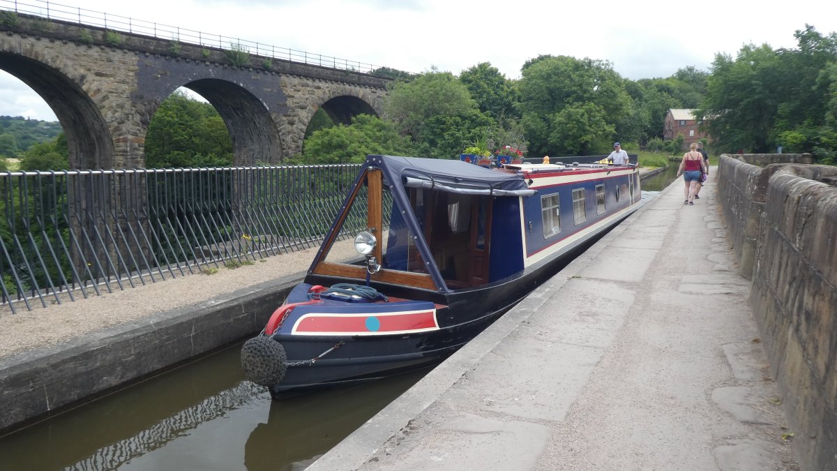
Here is Leo on the aqueduct and alongside is a railway viaduct. For those of you who have our 'business card' this is the view on the card, not the more famous and very similar aqueduct at Chirk on the Llangollen Canal. The railings have been added since we last came this way. Before then you could step off your boat on that side with no protection from the 100 foot drop.

Soon after the aqueduct the canal becomes much more wooded and has deep cuttings and a couple of tunnels as it crosses from the Goyt valley to the valley of the River Tame. This photo is looking back to Woodley tunnel. It is only 167 yards long and you can see the far end in the picture. Unusually this tunnel has the towpath continuing through it. More commonly the towpath goes over the top. Experienced horses often knew the route and would cross to the other side on their own.

This picture was taken close to the end of the Peak Forest Canal at Dukinfield Junction. Leo at this point is on an aqueduct over the River Tame. Another mill chimney dominates the picture.

Just the other side of this bridge is the junction with the Huddersfield Narrow canal to the right and the Ashton Canal to the left. The Huddersfield Narrow crosses the Pennines to reach its named city while the Ashton Canal, which we took, leads to Manchester.

Here is the sign at the junction.

Our next posting will cover our experience of the Ashton Canal which is only 6 miles long but has another 18 locks to descend to Manchester. The next posting will be pretty soon as we are now (Tuesday evening) moored close to the end of the Ashton.

Thursday, 20 June 2024

Macclesfield Canal - Rudder problems and more

 This posting to our blog describes our trip on the Macclesfield Canal which runs from Hardingswood Junction where it leaves the Trent and Mersey to Marple Junction 28 miles later. After a flight of 12 locks at Bosley the summit level of the canal is about 500 feet above sea level. We had a new mishap but also some lovely days and the summer weather seems to be finally arriving. So here goes:

Hardingswood Junction built in the 1700s bears a strong resemblance to modern motorway junctions. Though we turned left to join the Macclesfield Canal (known as the 'Macc'), the intention is to go right so fairly soon the canal turns right over the top of the Trent and Mersey which by this point has dropped down a couple of locks. So this picture from Poole Aqueduct shows us looking down on the Trent and Mersey.

Soon on the right we passed a line of hills with this folly on the skyline. It is called Mow Cop (Mow pronounced to rhyme with 'cow'). We have climbed up there before but didn't do so this time. It has a great view over the Cheshire plain.

This is Ramsdell Hall, a fine 18th century house by the canal near which we moored. Out of the blue we discovered that we had moored next to Mick and Suzanne Wilson who were responsible for fitting out Leo originally. It was good to see them again but what a coincidence!

From our mooring we walked about a mile west to visit Little Moreton Hall shown here. It was built in the 1500s and note the long gallery at the top of the house which was added later and whose weight very nearly collapsed the whole building.

Here is the view of the house from its internal courtyard.

At either end of the long gallery is a relief of which this is one. The attendant explained its significance apart from the spelling mistake on the left which should have said 'the sphere of destiny' not 'the spear of destiny'. This is the good lady who is dressed demurely and who is governed by learning and mathematics.

And here is the bad girl. Note the hoisted hemline and exposed breasts. She is ignorant, relies on luck to make her way in the world and has to sell her body to survive.

The turnover bridges on the Macc are famous. Such a bridge is needed when the towpath changes sides to get the horse across. But those on the Macc are designed so that you do not have to unhitch the horse from the boat in doing so. Note how the path over the bridge curves round on the left going through the arch of the bridge on the side where the boat is arriving.

As befits a canal planned by Thomas Telford the locks on the Macc are concentrated into a flight of 12 at Bosley. This view taken looking back from near the top shows the Cloud, a hill close to the canal which is almost 1,000 feet high. We had serious problems climbing these locks when, coming into lock 9 near the bottom, we scraped over a submerged baulk of timber which lifted the rudder out of its bearing cup. This has never happened to us before but we finished up with the rudder hanging from the the top bearing with nothing holding it at the bottom. The boat would still steer but clearly wasn't right.

This is Broadhurst Swing Bridge beyond the top of the locks. This had to be swung by Helen power before Leo could pass through.

The landscape of the Macc is pretty hilly and it was built with a lot of embankments and cuttings to flatten out the hills. In this photo we are above the Gurnett Aqueduct. The road below does actually pass under the canal. In one of the houses down below James Brindley, one of the most famous canal engineers, served his apprenticeship.

There are a number of very narrow sections on this canal where there used to be swing bridges. If you look at the left side of this one you can see a circular depression where the bridge used to swing.
 

We came into Macclesfield with our dodgy rudder and phoned a number of boatyards for assistance. One boatyard suggested we might be able to do it ourselves, so we spent a hardworking afternoon repeatedly lifting the rudder with wooden levers and chocks and then seeking to drop it in the right place in the bearing cup. We had pretty well given up when a coal boat, Alton, arrived and its skipper, Brian, said he would have a go. Now Ian couldn't lift the heavy rudder but Brian could and he tried and tried for an hour to drop it in while Ian used his toes to assess where the bottom of the rudder stock (its axle) was lying. Obviously the canal water is too opaque to see down very far and the bottom of the rudder is too low in the water to reach with hands. A boating neighbour, Alan, also gave valuable assistance. Anyway Brian finally managed it, though the rudder is now stiffer to use than it was. And for all his extreme efforts all Brian took away by way of payment was a bottle of beer and a pain au chocolate. People on the canals are so helpful: it is amazing!

The following day we carried on, passing Clarence Mill at Bollington. The CRT chaps shown right were looking for the location of a whirlpool where water was escaping from the canal. Since we passed the canal has closed behind us and they are seeking to mend the leak.

We moored on Tuesday night at Higher Poynton on this wide stretch of water. It is a lovely place. The wide stretch of water was caused by subsidence due to mining around here.

On Tuesday afternoon we had a good walk through the edge of Lyme Park. This building on the next ridge to our path is called the Cage and was used as a hunting lodge.

From the hills above the canal we could see the centre of Manchester in the distance.

We liked this fun boat with the front of Del Boy's Reliant over the bow and the back of the car over the stern.

We passed this creche of goslings with three adults on guard.

As we approached the north end of the canal at Marple we passed the huge Goyt Mill shown here.

And the very last yards of the Macc are only wide enough for one boat at a time. Note that here is another of the curvy turnover bridges. The other side of the bridge is the Peak Forest Canal which we joined at this junction. We turned right and we are now moored in Bugsworth Basin some 7 miles away from here. To the left is the top lock of the Marple flight of 16 locks.

Here is the sign at the junction. Back through the bridge where we had come from the sign points to Macclesfield and Stoke on Trent. To the left it points to New Mills, Bugsworth and Whaley Bridge and right to Dukinfield, Manchester and Huddersfield.

But all this is for another day.  Enjoy!

Friday, 14 June 2024

North to Stoke on Trent and beyond

We've passed another couple of canal junctions in the last two days and we are now on the Macclesfield Canal. So here are photos and an account of an eventful few days:

This photo is taken at Hoo Mill Lock shortly after Great Haywood Junction. Why the split bridge? The answer lies in the time when boats were hauled by a horse walking along the towpath. The gap in the bridge allowed the rope joining horse to boat to pass through as the boat was pulled into the lock.

Sunset on Tuesday while moored at Burston

A typical milepost on the Trent & Mersey. This one at Aston Lock marks the half way point on this canal, being 46 miles from each end. We are heading towards Preston Brook which is near Runcorn.

Arriving in Stone we passed this fine building which was once the workhouse and is now converted into flats. The green flag is from the Environment Agency.

Coming through Stone took us past the old Joule's Brewery shown here. Actually the beer is now brewed in Market Drayton, but we were able to sample some which was very quaffable.

By Newcastle Road Lock in Stone this tunnel crosses under the road beside the lock. It was originally built to take the horses through to re-attach to the boat below the lock.

Leaving Stone we soon came to the four Meaford Locks.

Coming into Stoke on Trent we crossed this aqueduct where the canal narrows. This was our last encounter with the River Trent which comes in from the east at this point from its source a few miles away. It is little more than a stream here.

I couldn't resist the name!

So who is this dancing gent? This is 'Rob The Lock' who makes it his job to help boaters through the locks round here. We had earlier met Rob at Trentham Lock where he was waiting for his single boater to help up the Stoke Locks. You are very likely to meet him if you are going through locks in this part of the world, as we have done in previous years. He uses a bike to get between the locks and this photo shows where we met him again at Stoke Bottom Lock. For those that know Rob the big news is that he got married in February and he was proud to show off his wedding ring and a picture of his bride. Good to see you again, Rob!

Lock 2 in this flight of 5 deep locks passes under the railway shown here and then rises above it.

Near the top is the Etruria Bone and Flint Mill shown here. On a few days a year the steam engine that powers this is going, but not when we passed.

And this is Etruria Junction shown looking back from near where we moored having arrived in Stoke. To the right is the top lock of the Stoke flight which is extremely deep (perhaps 12 or 13 feet). To the left the Caldon Canal branches off and runs for 17 miles to Froghall in the Churnet valley with a short branch to the town of Leek. We stayed straight ahead this time on the Trent & Mersey.

This morning we carried on through Stoke passing the Middleport Pottery. For TV addicts, this is where the Great Pottery Throwdown has been filmed.

Only a few pottery kilns remain from the hundreds that used to characterise Stoke.

A few miles north of Stoke we came to the Hardcastle Tunnel shown here. We had to wait our turn as boats only pass through in one direction at a time. The tunnel does not have any ventilation shafts so, once you get into the tunnel, a door is closed and powerful fans drive a flow of air from north to south. This made the passage through pretty chilly. The tunnel is more than a mile and a half long and takes over half an hour to get through. When we got to the north end the sun was shining!

Water flows into the tunnel bore from drains that take it around the structure. The water becomes stained this orange colour by iron ore deposits. And yes, some water did fall on our heads from drips coming through the roof.

And here is our last junction for today - Hardingswood Junction where the Macclesfield Canal heads left under the bridge to leave the Trent & Mersey. Straight ahead you can see the top locks that start the long descent from here on the Trent and Mersey towards Middlewich and Runcorn. We turned left here onto the 'Macc'.

Here is the sign at the junction. This shows that we have come from Stone and are heading towards Congleton and Macclesfield and ultimately to Manchester, 43 miles away. Hardingswood Junction resembles modern motorway junctions though it is obviously much older. Having turned left at the junction by this sign, the canal swings right to cross the Trent & Mersey on an aqueduct, the latter having dropped down 2 locks by this point.