Friday 30 August 2013

Out on Tidal Water to Denver Sluice

Well we've done it!  We've completed the final part of the crossing from the River Nene to the River Great Ouse today.  This entails a short section on the tidal River Ouse which has to be timed carefully for the tides so that boats can safely cross without being swept upstream or downstream out to the Wash.

On Thursday we had a short day from March to Upwell as we did not have time to reach Salter's Lode (where you join the tidal river) by midday which was the allotted time to go out of that lock.


The fens are completely flat and ideal for windfarms like this one we cruised through.


The villages of Upwell and Outwell have roads either side of the river with houses lining those roads facing the river, which at this point is narrow and pretty shallow.  This is the view looking towards Upwell Church.


Yesterday afternoon we cycled out into the farmlands round about.  Wheat, pumpkins and sugar beet were the main crops but we also saw a few cows and sheep.


Most of the houses round here have a plaque with a name as well as a date.  Many houses seem to have been built between 1908 and 1912, presumably for agricultural workers.  This particular house had an interesting name.


Here is a close up of the plaque with its name!

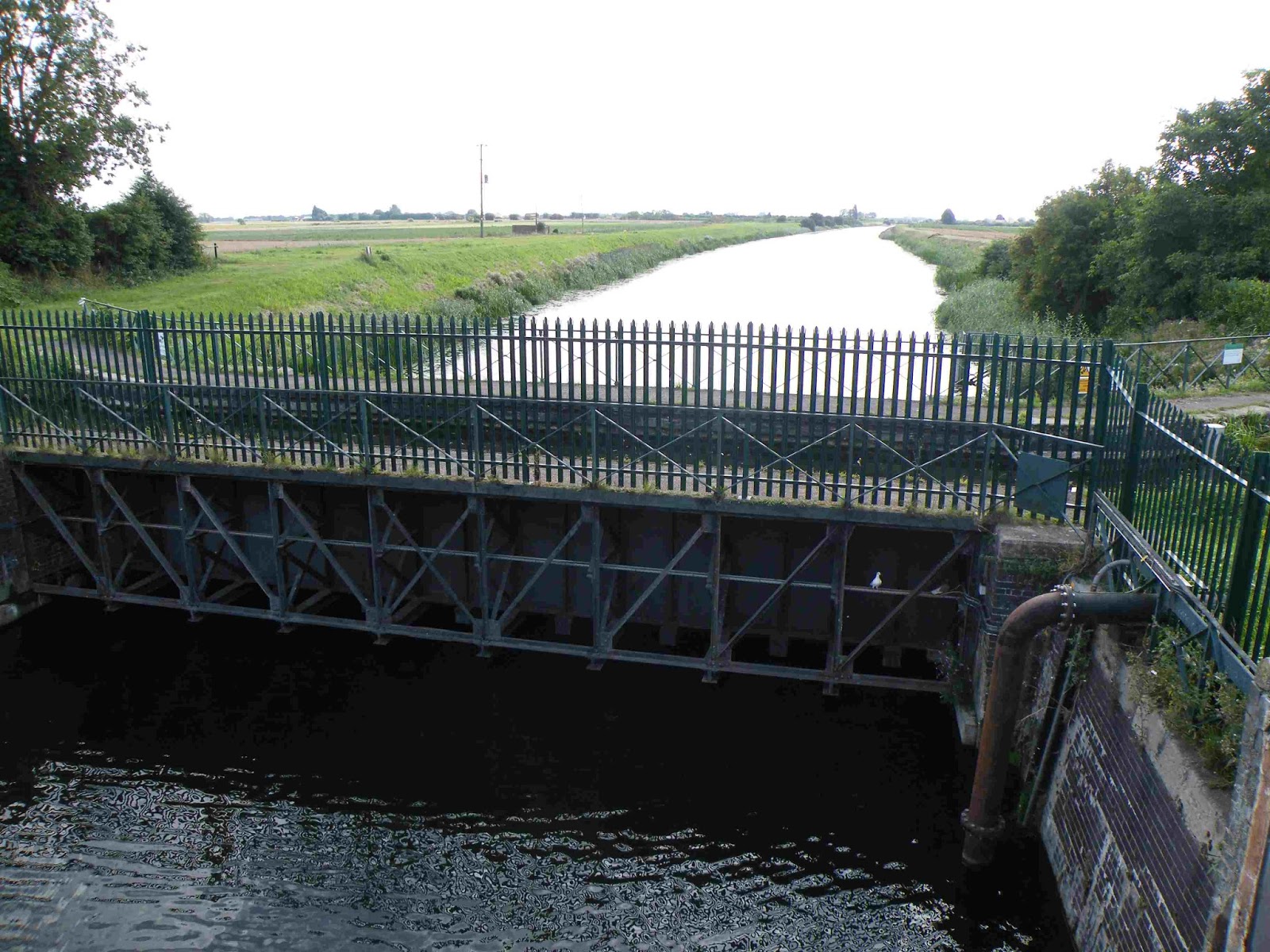
On our ride we came to this aqueduct which we crossed this morning.  This is Mullicourt Aqueduct which takes Well Creek across the Main Drain which carries on as the Sixteen Foot Drain.  The lower water joins to the main route through the Middle Levels but below Marmont Priory Lock that we came through yesterday.  The water at the lower level is in fact below sea level.


And so today, having crossed this aqueduct and covered a few more miles we came to Salter's Lode around lunchtime.


Here is Leo waiting for the moment to go into the lock (under the bridge) and so out to the tidal River Ouse which connects to the sea at King's Lynn.


Here is the other side of the lock.  The wall covered in tyres is to receive incoming boats which tend to get swept by the tide in turning into the lock.  We had to turn right upstream.


Here is the view upstream for half a mile to Denver Sluice.


The Salter's Lode lock keeper, Paul, warned us that there was a chance that we would not be able to make the crossing.  It is the time of low tide range (Neap tides) and the wind was against the tide.  In these circumstances there is a possibility that the tide will not arrive at all up here.  However we were in luck but only just.


Here Leo comes into the lock.  The other side of the gate in front is the tidal river.


Having come down about 3 or 4 feet in the lock the gate opens and out ahead you can see the river.  The Lock Keeper gave advice how best to avoid the mud banks outside.


Here we are part way out, stuck on the mud.  Again Paul's advice was crucial - go backwards and forwards to plough a channel through the soft mud until the boat breaks through into deeper water.  


Here is Helen's view from the bow with Ian following the advice and driving Leo forwards and back until, very slowly, with lots of throttle the boat began to move through the mud.  The bow started to float and soon the stern followed allowing us to turn right across the river and follow this upstream to Denver.


Looking back you can see the guillotine of the lock and the wall of tyres.  We're off.


Here we are approaching Denver Sluice.  To the left is the gate opening to the lock.  We had been told to go very close to the mooring pontoon (this has the red sign on it) and power towards the lock to avoid similar mud banks here too.


The lock keepers at Salters Lode and Denver are full of helpful advice and are continually casual and reassuring to boaters.  They are a wonderful pair.  Once in the lock at Denver we came up easily to the safer non-tidal Great Ouse.


We had forgotten quite how big and wide is the River Great Ouse.


 A mile or so upstream we turned off to cruise the River Wissey, a smaller tributary of the Ouse.


The Wissey is small, tree lined and twisty.  It has been a delight so far.


A few miles upstream is this vast factory built in the 1920s.  It is a sugar factory extracting the white stuff from sugar beet.  A strange smell most similar to yeast pervades the countryside hereabouts.


Just beyond the factory the river flows through a couple of sizeable lakes.


And this is where we are tonight, tied to some trees on a bank cleared by some previous boater.  We have the sound of sheep for company, unlike last night where noisy tractors and lorries shattered the peace of the village of Upwell.


Tomorrow we'll press on to the navigable limit of the Wissey about 11 miles from the Ouse.  On Sunday we have Lucy and her friend Kathryn coming to join us for the day.  So we need to make sure we're back on the Ouse to pick them up at Littleport, North of Ely.  Now that we've passed Denver Sluice we are well on our way to reach Bedford which will be the end of the line for our sortie on the East Anglian Waterways.

Wednesday 28 August 2013

Out on the Fens - The Middle Levels

We've now completed our cruise down the River Nene to Peterborough and we are now on the flood drains that constitute the Middle Levels and connect the Rivers Nene and Great Ouse without the peril of going out to sea on the Wash.

On Friday we continued down the Nene passing through Thrapston which marks the change from calling the river the 'Nen' to calling it the 'Neen' which is more how it is written.


 This is the bridge at Thrapston.  Some of the bridges on the Nene area a bit tricky with the current in the river.


That evening we moored below the lock at Titchmarsh and went on a cycle ride around the neighbouring villages.


This is Wadenhoe Mill with a lovely clear mill stream and some fine large fish swimming around.


We followed a path across from Achurch to Wadenhoe and here is a view from a distance of Wadenhoe Church.


We popped in to the King's Arms in Wadenhoe which is a lovely village reminiscent of some fine Cotswold villages.  The garden of the pub stretches down to the river and, at the bottom of the garden, who should we see moored but Chris and Cliff on 'Tihso' who we met and spent time with in Liverpool last year.  It was good to catch up with them.  On Saturday we carried on downstream to Fotheringhay, where Mary Queen of Scots was executed.


Here we are passing Tihso on a wet morning on Saturday.


This waterfall over the top lock gates was not because of the rain.  In fact many of the Nene locks do this which makes filling the locks much easier.


Fotheringhay Church stands proud above the fairly flat lands round about.  It really is a splendid building.

 Here we are moored for the night just above Fotheringhay Bridge.  The grey cloud shows the rain that was about to arrive and duly did.  We watched the level indicator by the bridge carefully during the evening and night.  Fortunately the river only rose by about 5 inches so we could still get under the bridge in the morning.


Here you can see the river and bridge to the left , the tower of the church in the middle and the mound of the castle to the right.  There is nothing left of the castle now apart from the mound.


Here is the memorial to Mary Queen of Scots who was imprisoned in the castle and later executed.


Apparently Mary planted thistles presumably to remind her of Scotland.  Perhaps these were descendants of those she planted.


On Sunday we found a lovely mooring beside Alwalton Lock and on Monday we carried on to Peterborough stopping en route at Ferry Meadows, a park for the locals beside a lake with a link to the river.  You can take your boat onto the lake and there are pontoon moorings for visitors.


Being Bank Holiday the Nene Valley Railway was running and we went underneath just as the train went overhead.


Here is Milton Ferry Bridge a lovely ornate bridge across to the Ferry Meadows park.


Here is Leo moored on Lake Overton at the very nice visitor mooring pontoons.  Cars have to pay to park but boats are free for 24 hours!


Here we are setting out to explore the lake.  Looks like we are setting out to sea.


On Monday evening we were pleased to welcome Graham and Trina onboard.  They were tired after a day spent travelling but we were delighted to show them the boat and our home for the summer.  Graham was Ian's boss in respect of Union casework and the two have often resorted to a local ale house to discuss Union business.

On Tuesday morning we had only a short while to see the highlights of Peterborough.


This is the West front of the Cathedral seen from the Cathedral precincts which are secluded, quiet and delightful.


And here is the market building nearby.


Our time was limited because we had a morning booking for Stanground Lock which takes boats down from the river onto the Middle Levels.  Yes, you did read that correctly.  The river is usually the lowest point in a valley but this is the Fens and things are not quite like this.  Some of the Fens is below sea level, hence going down from the river level.  The Middle Levels is a collection of interlinking drains and ditches and old rivers that links the Rivers Nene and Great Ouse.  A few miles on you come to the town of Whittlesey and a very sharp bend.  Fortunately we knew this was coming and did just get round without touching the bank.


The water channel is very narrow and lined with hard sides.


Here is the sharp bend to the right and under another bridge.  Very tricky.


Whittlesey was a fine small town where we lunched at the local Wetherspoons for under a tenner for two meals and two drinks.


In the main square is a fine thatched building.  I admired this straw man on the top of the roof.


Here is the old town hall.  We were particularly struck by the arched doorways to either side of the entrance door.


Here is a detail from the picture above and you will see that the old fire engines (probably hand carts) went through the arched doorways.


So what are the Middle Levels like?  Well the country is pan flat, the waterways can be dead straight but not always and the towns seem isolated but interesting.  We left the main route through the Middle Levels to follow the old course of the River Nene to Benwick and Ramsey and today have come back to March where we are presently moored.


How's this for a straight waterway?  Some straights are only a mile long, others are six miles long.  The skies are enormous, trees are few and the water is amazingly clear down to 5 or 6 feet down.  You can see the fish clearly.


There are some low bridges.  This one just brushed the chives on the roof.  Some are only 5 feet above the water and we can't manage those.  So you have to be careful which waterways you follow.


With high banks along the waterway, we have found this is the best way to see the views.


Approaching Ramsey the channel got very narrow and we brushed through the weeds on either side.


Here Helen is watching Ian turn Leo in a very tight turning hole at the end of the waterway at Ramsey.  It is a good job that Leo is not a 70 foot narrowboat!


This is Leo on autopilot.  On the long straights only an occasional tweak is required to keep her on track along the waterway.


Here are the town centre moorings in March.  The prominent building with the tower is the Victorian Town Hall.  We are moored a little further out of town.


Tomorrow we will go further along the main route through the Middle Levels so that on Friday we can do the perilous crossing of the tidal waters to Denver Sluice.  This is only half a mile on tidal water but if we make a mess of it then the next posting will be from Holland.  However if we make it then we will be cruising up the River Great Ouse to Ely, Huntingdon and Bedford.

Thursday 22 August 2013

Cruising the Nene

We've had a couple of days now cruising the River Nene from Northampton towards Peterborough and mostly we're really enjoying being back on a river again.  On Tuesday we came down the 17 locks of the Northampton Arm which links the Grand Union Canal with the River Nene at Northampton.  It was quite a hard day but it was great having the pleasure of narrow 7 foot locks once again.  We hadn't seen these since we left the Oxford Canal in late May.


This photo was taken as we came out of the top lock of the 17.  You can see how the lock neatly fits Leo's width.  A narrowboat glides into these locks without touching the sides almost by magic.


Down the flight there are a few lifting bridges.  Fortunately all of them were held in the open position so making life easier.


On the way down we devised some new techniques to make life easier.  Here Helen is using a boat hook to push open the offside bottom gate, so saving either Helen walking round the lock or Ian climbing the ladder out of the lock and then back down again.


And here is Helen closing the gate.  First Ian pushed with the other boat hook (we now have two as we found one a few weeks back) on the lock gate beam and Helen finished off by pulling the gate fully closed.


Part way down are these curious bent wire statues of a boat man pointing up the flight and his lady sitting on the bench.  The other one sitting is not a wire statue!


Here is a lock almost underneath the M1.  This is close to Rothersthorpe Services but the canal is pretty difficult to see from the motorway because of the trees either side.


The main problem of the Northampton Arm was not the lock flight but the very weedy channel from the bottom down to the river in Northampton.


A bit like the African Queen this.  A very narrow channel in the middle with reeds growing and lying in wait to wrap round the propellor.


This bit was even narrower.  Good job there was nothing coming!


Here we are looking back to the last lock that gives access to a short channel linking with the River Nene.


Not wanting to do any more on Tuesday we moored by the Yellow Bridge in the city.  We visited Morrisons which is close by and had a walk round the centre in the evening.

The last two days we have cruised down the river.  The locks here are quite different to the canals.


This is Abington Lock which has conventional gates but the continuous waterfall over the top gates meant that it was barely necessary to open the paddles to fill the lock.


This is not a lock, but into and out of the Northampton Washlands you go through flood gates like this one which can be closed in times of flood.  The Washlands is an area of land that is deliberately flooded to divert some of the floodwater when needed.


The commonest sort of lock has the usual 'V' doors on the upstream side and a guillotine like this one on the downstream side.  These are nearly all electrically driven but take an age to open or close.  To release the water in the lock the guillotine gate is opened slightly at first to let the water out.  We've learnt to use a stern rope to counter the tremendous pull on the boat when the gate is opened.  It is certainly a quick way of emptying a lock.


This is Ditchford Lock which has a radial gate on the downstream side.  This takes even longer to open or close and drips more when you drive underneath it.


Yesterday evening we cycled into Earls Barton which is a nice village with probably the best preserved Saxon tower in the country.


Here is the Saxon tower but the rest of the church is later.  Even the clock worked, but perhaps that was newer than the tower.


This was a memorial in the churchyard.  I'm not sure you can read it on the blog but it is a memorial to a local flour miller "Mr Thomas Whitworth husband of Rebekah Whitworth also husband of Sarah Whitworth".  Clearly bigamy was rife here in the eighteenth century!


Here are a selection of other sights from our travels down the Nene so far:


The river is amazingly wide across the Northampton Washlands but becomes narrower and more twisty further downstream.


Just to give an idea of how clear the water is here, this is a picture looking down into the weed hatch showing Leo's propellor.


The little foal on the left was one of several at Earls Barton last night.


The Environment Agency do love their Health and Safety notices.  We haven't seen one yet for don't walk across the lock gates which Ian had to do today to clear the weed before we could close the gates.  If the top gates are not fully closed then the electric guillotine gate will not operate.


Here is the concrete viaduct carrying the A6 over the river.  It was built in 1936.


And here just a few yards downstream is the old stone bridge which dates from the 14th century.


For the next few days we'll be continuing our cruise down the Nene until we get to Peterborough.  If the last two days are representative then it should be a fun few days.