Friday 28 June 2024

The Infamous Rochdale Nine

 As promised, here is our account of travelling down the 9 locks of the Rochdale Canal that take boats down through the centre of Manchester from the Piccadilly area at the top to Deansgate and Castlefield at the bottom. These locks carry a bit of a reputation as two of them lie underneath modern high-rise buildings where in the gloom druggies and prostitutes are said to do their business. The canal also passes parallel to Canal Street which is now the centre of the gay community in the city. This is the first time we have taken Leo this way and there are not that many places left where Leo hasn't been. So here is the story of our 'first' for 2024:

On Tuesday night we stayed in Piccadilly village so it was on Wednesday morning that we went to the very end of the Ashton Canal where it meets a 'T' junction with the Rochdale. To the right lies an ascent over the Pennines. To the left lie the 9 locks. The picture shows the first lock, number 84 with Leo entering. Note that we are now in broad lock land as 2 narrowboats would fit side by side in these locks.

Once down lock 84 you are in a cavernous space below buildings for the next two locks. The pillars in front of Leo support the tall buildings above. Fluorescent lights allow boaters to see what they are doing.

Here Leo is in lock 85. The towpath, which is not continuous through the 9 locks, carries on down a ramp on the left.

Helen took this photo of Leo coming in to Lock 85. Best not to ask what is floating on the water!

After the two 'underground' locks we came to lock 87 which is in the open air and right alongside Canal Street. Note how the wall is carved out to allow boaters to operate the lock gate.

Sometimes there is just not enough space for the lock beam, so here an ingenious alternative solution uses a chain linkage powered through a gear box by your windlass to pull the gate open or closed. The steep steps beyond the apparatus lead down to a landing where the lock crew (aka Helen) has to get back onboard as there is no towpath to the next lock.

A narrow channel between modern buildings and an old warehouse lead on to lock 88.

And here Leo is in lock 88 before Helen opened the downstream paddles to let the water out. Another subterranean section leads out of this lock under the white building.

Nearly there! Leo is shown coming out of lock 91 which is shallower than most of them. The diagonal staircase leads up to Deansgate Tram stop.

The bottom lock no 92 has a traditional lock keeper's cottage which looks out of place among all the high rise modern buildings. Ian is using our alternative to a bow thruster, namely brawn to push Leo to the other side of the lock.

Below the locks there are opportunities to moor in basins to left and right. Because a festival was to take place to the right, we went left into Castlefield Basin shown in the picture where we found a mooring. Handily you can walk across from Lock 92 to see if there are spaces.

Fortunately you can turn a boat at the end of the basin, so here Leo is safely moored facing to go out after a couple of days exploring some of the city sights.

One that we did want to see was an old railway viaduct now owned by the National Trust and planted with both wild and cultivated plants. It was pretty hot on the day we arrived but there were some trees for shade in the garden in the sky and the NT building at the end is air conditioned.


We haven't previously found any attractive streets of old buildings in Manchester but this is St John Street which brought back memories of Bath.

And here is the John Rylands Library building, a wonderfully exuberant Victorian Gothic monument to the philanthropy of Rylands and his cuban wife Enriqueta. Rylands made his money in cotton. Manchester is sometimes referred to as 'Cottonopolis'.

On Thursday we walked along the Bridgewater Canal to Salford Quays. As we left the Bridgewater we came upon this intriguing crane hook suspended from nowhere. Behind is a warehouse built in 1932 for incoming cotton arriving by rail rather than canal.

At Salford Quays, we particularly wanted to visit the Imperial War Museum North which opened in July 2022. We were frankly disappointed. It is a very individual peculiar shaped modern building but inside there was no natural light, bizarrely sloping floors and leaning walls which made us both feel a bit dizzy at times. There was lots of space inside but remarkably few exhibits. One that did affect us was this steel window from one of the Twin Towers and the accompanying recorded accounts from some survivors. But overall probably best avoided, though it is free! We much preferred the Lowry (also free!) on the other side of the Manchester Ship Canal.

We walked over the Millenium Lift Bridge and this view was taken from the bridge looking towards Liverpool. The BBC Salford building is on the right.

We are now on the Bridgewater Canal and we'll tell you more about that another time. It has one significant advantage after several days doing lots of locks - it doesn't have any!

Thursday 27 June 2024

The Ashton Canal

 In an effort to catch up with our speedy passing of canal junctions, here is our account of travel down the 6 or so miles of the Ashton Canal into Manchester:

You may remember that we came to the end of the Peak Forest Canal at Dukinfield Junction and there turned left onto the Ashton Canal. The Ashton has a reputation for passing through rather unsavoury parts of the outskirts of Manchester but we found that things have much improved in the 12 years since we last passed this way. Nevertheless we decided not to chance mooring overnight on the Canal and instead booked a night in the small marina at Droylsden. You might be able to make out Leo fourth from the right on the moorings. We spent the afternoon walking the three and a half miles down the Canal into  Manchester and getting the tram back.

There are 18 locks down into Manchester and here is the first one close by the marina. Originally there were two locks side by side but the right hand one is no longer operating.

Here is Leo going down in the first lock.

Below the first lock (actually this is no 18 as they are numbered from the bottom), is a boathouse seen here on the left looking back.

Early on in the flight we had problems with a very low pound and, from then on, we positioned Leo against the top gate of each lock with the engine at low revs pushing against the gate. This meant we did not have to moor by the side of the canal where it was likely to be too shallow. Getting stuff round the prop was also a problem and Ian had three trips down the weed hatch to clear things. As well as a lump of timber that stalled the engine we caught a fleece, a pair of knickers, swimming trunks, plastic waste and lots of weed!

By the new Co-op Live arena at lock 5 a man-powered butty passed us coming up.

There is a lot of new development going on at the Etihad Stadium. No wonder football teams are so rich.

Though it now seems safer, no-one would describe the surroundings on the Ashton as pretty!

A new bridge has been put in to access the Velodrome.


Here we are coming into the city towards the bottom at Lock 1. Manchester has a lot more high rise buildings since we were last here and yet more are being built.

Here is Leo waiting for Lock 1. The low rise development beside the Canal below the lock is Piccadilly village which dates from 1990 and was where we were planning to spend the night.

And our good fortune continued as there was space for us on the offside away from the towpath. This is outside a residential development and ordinarily might be marked 'Private: No Mooring' but in fact they permit boats to moor for 24 hours. You cannot however get out from the development to the rest of the world. However a quiet afternoon suited us fine.

This splendid rose was in the private estate gardens of Piccadilly village which visiting boaters can access even if they can't get out of the development through the locked gate.

So now we were positioned in a great place to take on the 9 final locks of the Rochdale Canal into the bottom end of Manchester at Castlefields. These are known as the 'Rochdale 9', carry a fearsome reputation with boaters and we had never tackled these locks in Leo until now. But that story will have to wait for the next posting on this blog in the next day or so.

Tuesday 25 June 2024

Peak Forest Canal

 This posting covers our experience on the Peak Forest Canal. This runs from Bugsworth and Whaley Bridge to Dukinfield Junction where it meets both the Ashton and the Huddersfield Narrow Canals. In the middle lie the Marple Locks, a flight of 16 leading down to the valley of the River Goyt. The Peak Forest has some spectacular scenery and its upper section lies part way up the side of the Goyt valley with views towards Kinder Scout and the other hills of the Peak District.

So here is the account of our journey on this canal. At Marple Junction where the Macclesfield meets the Peak Forest we turned right for 7 miles to the terminus at Bugsworth Basin. We then turned round and retraced our steps to reach the Marple Locks and beyond.

In the 7 miles between Marple and Bugsworth there are four lift or swing bridges, only one of which is power assisted. This one is Turf Lea Lift Bridge which is Helen powered by turning a windlass umpteen times to lift the bridge.

And this is Higgins Clough Swing Bridge which is also Helen powered using a lever to open the bridge.


Near the end of the canal a short branch goes south to Whaley Bridge. A horse tunnel beneath the canal shown here allowed horses to leave the main canal and follow the Whaley Bridge branch. You may remember that Whaley Bridge was nearly inundated a couple of years ago by a failure of the dam of the Toddbrook reservoir. The reservoir has yet to be filled with water after the necessary repair.

Bugsworth Basin was built as a transhipment place for limestone and other materials brought down from the hills on horse-drawn tramways. It has a number of arms and the pictures shows Leo moored in the Upper Basin.

To the left here is the lower basin with channel to the right leading to the middle and upper basins. It is a super spot and we stayed there for a few days.

Last Thursday from Bugsworth we did a 10 mile hike in the hills towards Edale. The original intention was to get the train to Edale and walk back but the train we needed was cancelled. The picture shows Cracken Edge above the village of Chinley. This has numerous old quarries along the line of the rocky cliffs shown.

Having walked the length of the Edge, we dropped down and then climbed South Head closer to Kinder. Cracken Edge can be seen now in the distance.

This lamb was keeping a close eye on the activities of the humans.

The cairn marks the top of South Head and the picture is taken looking north west towards Manchester which we could see in the distance.

The edge of the Kinder Scout plateau could be clearly seen from South Head. The plateau is at around 2,000 feet above sea level and we were about 1,650.

These adolescent male Highland cattle eyed us with interest as we found our way back to Bugsworth.

Having left Bugsworth on Leo we moored for the night on Saturday close to the top of the Marple locks and  high above the Goyt valley. An interesting walk took us down to the river and along it to Mellor Mill of which the photo shows the excavated remains after it was demolished by fire. The cotton mill was the largest in the world when it was built in the 1790s. It was originally powered by water and later by steam engine.

This view gives an idea of the outlook from the Peak Forest Canal. Wonderful.

As we came back down a hill towards our mooring this was the view which we think is looking back towards the high hills around Bugsworth.

On Sunday we descended the 16 Marple locks. In this view as we approached the top lock, the Macclesfield Canal comes in under the bridge and the locks lie to the right.

The Marple Locks are really deep as this shot shows. The flight drops 214 feet in 16 locks, so an average of 13 feet 4 inches each! Some are even deeper than this.

Here we are looking back towards the top lock from the second one down. The residential road to the right follows the lock flight down the steep hill.

Between locks 13 and 12 (they are numbered from the bottom) the canal passes under a road and to the right you can see another example of a horse tunnel.

The large stones used to build the locks sometimes, as here, have characteristic marks made by the stonemasons who each had their own mark.

This warehouse was built in the early 1800s by Samuel Oldknow who also built the Mellor Mill already mentioned.

Lock 7 was substantially rebuilt over last winter and was only reopened about 10 days before we used it. As you can see quite a lot of new stone was used in the rebuilding.

Here we are approaching the bottom lock of the flight. The chap in the blue is a CRT person who helped us down the flight by setting each lock ahead of us. As a result partly of his help we got down the  16 locks in a little over 2 hours!

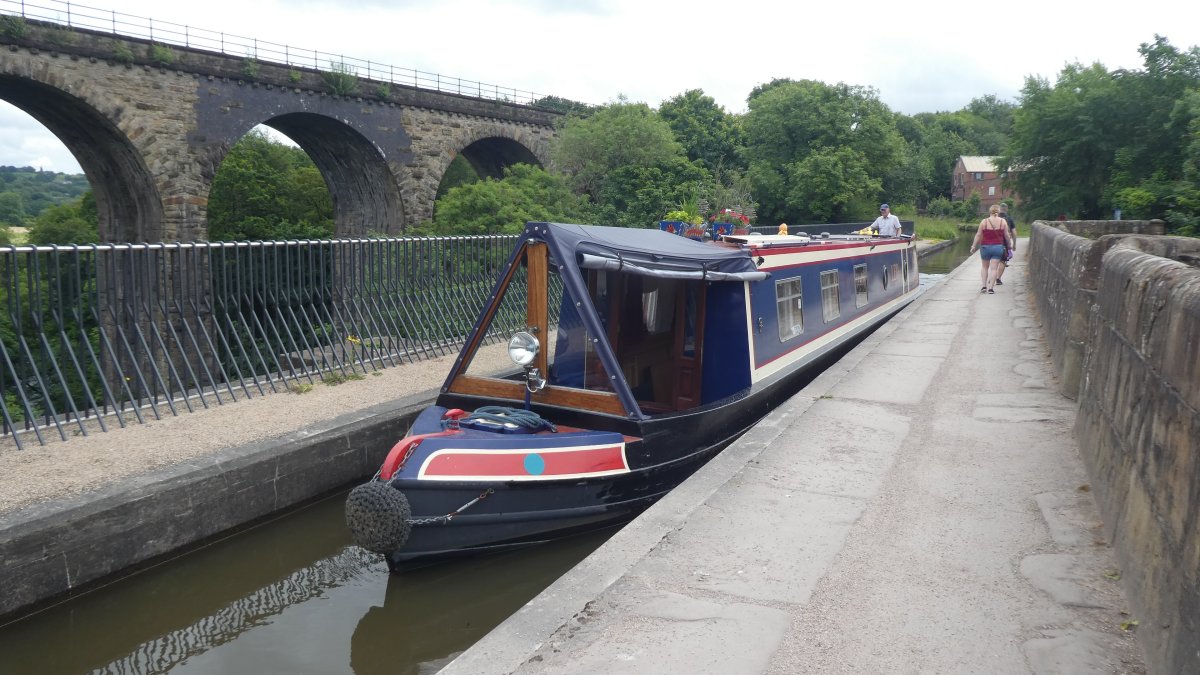
Below the locks the canal crosses the River Goyt by means of an aqueduct about 100 feet above the river. The view down is quite vertiginous.

Here is Leo on the aqueduct and alongside is a railway viaduct. For those of you who have our 'business card' this is the view on the card, not the more famous and very similar aqueduct at Chirk on the Llangollen Canal. The railings have been added since we last came this way. Before then you could step off your boat on that side with no protection from the 100 foot drop.

Soon after the aqueduct the canal becomes much more wooded and has deep cuttings and a couple of tunnels as it crosses from the Goyt valley to the valley of the River Tame. This photo is looking back to Woodley tunnel. It is only 167 yards long and you can see the far end in the picture. Unusually this tunnel has the towpath continuing through it. More commonly the towpath goes over the top. Experienced horses often knew the route and would cross to the other side on their own.

This picture was taken close to the end of the Peak Forest Canal at Dukinfield Junction. Leo at this point is on an aqueduct over the River Tame. Another mill chimney dominates the picture.

Just the other side of this bridge is the junction with the Huddersfield Narrow canal to the right and the Ashton Canal to the left. The Huddersfield Narrow crosses the Pennines to reach its named city while the Ashton Canal, which we took, leads to Manchester.

Here is the sign at the junction.

Our next posting will cover our experience of the Ashton Canal which is only 6 miles long but has another 18 locks to descend to Manchester. The next posting will be pretty soon as we are now (Tuesday evening) moored close to the end of the Ashton.