This posting tells you about our cruising so far on the Middle Levels. This network of waterways helps in draining the Fens and also, for boaters, links the Rivers Nene and Great Ouse without having to venture out onto the Wash. To join the Middle Levels at Peterborough you have to lock down off the River Nene, an intriguing prospect and, at Whittlesey, we locked down again. So we reckon we are now below sea level.
We've cruised some new waterways where Leo has not been before and enjoyed some challenging boating as you will read below.
We moored overnight last Wednesday on the embankment at Peterborough and on Thursday morning had a look round the cathedral and the town before leaving around 11 am.
 |
| As you can see it was raining as we left Peterborough. The picture shows us turning right off the River Nene under the bridge onto Morton's Leam, which leads to Stanground Lock. To go through Stanground you have to book the day before. |
 |
| And here we are arriving above Stanground Lock in the pouring rain. The two chaps in the yellow jackets were from the Northern Levels. Helen went looking for the relief lock keeper, Julian who then let us down about 4 feet onto King's Dyke the first part of the Middle Levels. |
 |
| King's Dyke is reasonably wide and much like a canal leading past old brick works and the pits from which they dug the clay to make the bricks. The 'Mc Cain' sign makes it look as if the factory now makes crisps rather than bricks. Ian feels sorry for the little pig in a house made of crisps. |
 |
| As we approached Whittlesey the channel narrowed and then there was a very sharp right bend. You really do have to slow down for this one but the guide book says that some 70 foot narrowboats have managed to make the turn. At 57 feet, we did it without use of pole or crashing into the side this time, but it's not easy. |
 |
| And here we are having rounded the bend. |
 |
| Moorings on the Middle Levels are sparse. There are public moorings in Whittlesey but only for a couple of boats and these were full. So we managed to hang off the end of the moorings with a rope ashore at the stern and used our gangplank again. |
 |
| The rain stopped and we walked into Whittlesey. This walled space was originally the pound where stray animals were rounded up for collection, but now it is planted by volunteers and makes quite a show. We had done our research and carried the spent engine oil from the recent engine service to the recycling centre maybe half a mile from the Dyke. We then had a walk round the town which has a few fine buildings and some shops. |
 |
| This is the landlubbers' view of King's Dyke close to the very sharp bend. |
On Friday we carried on following Whittlesey Dyke to Flood's Ferry where there is a junction. We turned right on the old course of the River Nene (the history of the waterways round here is pretty complicated). This took us to Benwick.
 |
| Just below the public moorings at Whittlesey is Ashline Lock which goes down about 7 or 8 feet. Like the other locks here it is 11 feet 6 inches wide, so don't try sharing with another narrowboat! We think the paddles were full of weed as it took ages to fill. |
 |
| Here is Leo finally leaving Ashline Lock. There was quite a bywash coming out below the lock so presumably the drainage chaps were moving water from one section to the lower section. |
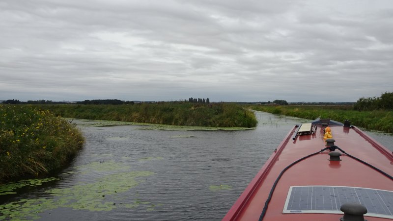
 |
| The Fens are famous for big skies as this shot along Whittlesey Dyke shows. Some of the channels are very straight and have high banks so the best views are from standing on the roof of the boat as Helen was in taking this picture. |
 |
| A few miles from Whittlesey we crossed a waterways cross roads at Angle Corner. The waterways both sides are navigable. Right is Bevill's Leam which runs for several miles before you have to turn round at a sluice. Left is the Twenty Foot River which can be used but has some impossibly low bridges, so not for Leo. |
 |
| Here is the sign at Angle Corner. |
 |
| It is a rare event here to meet other boats but we did. |
 |
| Here is the sign at the next junction called Flood's Ferry where we turned right off the main link route from Nene to Ouse. The turn takes you onto the old course of the River Nene before Vermuyden and his Dutch cronies were engaged to drain the Fens in the 17th century. |
|
 |
| This is the junction at Flood's Ferry. It is quite an acute turn if you are going right as we were. |
 |
| Amazingly the single mooring at Benwick was free so we used it. Just as well as the heavens opened again soon after we tied up. Later it did clear up and we walked round the village which, as you can see, has a shop and a pub. |
 |
| What Benwick had but no longer has is a church. Both the Victorian parish church and the methodist church fell down due to subsidence. This grassy bank is all that remains of the parish church. As the peat in the Fens dried out there was widespread subsidence and we noticed that most of the houses in Benwick are relatively new. |
 |
| This gravestone is a good demonstration of what can happen. |
 |
| Benwick in Bloom's answer to this poor looking site was to weave woollen designs into the netting around it. |
 |
| After we came out of the village shop the sun shone for an hour or so, but later this lot arrived. Fortunately we were back on Leo by then. |
Saturday saw us carrying on up the old River Nene to the Forty Foot Drain (good names round here). A right then a left took us up Ramsey Lode to moor at Ramsey for the night.
 |
| The Forty Foot Drain brought us to Lode's End Lock seen through this bridge. Our way lay left just before the lock into Ramsey Lode which is very narrow and pretty weedy especially past the entrance to a reasonable sized marina at Bill Fen. |
 |
| Just over a mile down Ramsey Lode is the end of this waterway. It is just possible to turn our boat there. You need to put the bow to the corner in the left of this picture and then power the stern round. A 60 foot boat might be able to turn but anything longer would not. There is also enough space to moor a single visiting boat, but that then blocks the turning point. However no-one came so we spent Saturday night there. |
 |
| Ramsey had a large abbey but little remains today except this gatehouse which now functions as the entrance to a school. |
 |
| The green by the church and the abbey gatehouse is delightful. The main street of Ramsey is called Great Whyte. It is extremely wide and has the continuance of the Lode in tunnels beneath it. We spent a pleasant afternoon at the Ramsey Rural Museum on the edge of town. Lots of old farm machinery and a reconstructed Fens cottage but the best exhibit was a two hole privy. Very friendly! |
Sunday was our day of adventurous boating following waterways where Leo has not been before. We retraced our outward route to Lode's End Lock and then through it to new waterways:
 |
| Now Lode's End Lock was a bit of a novelty in that the levels both sides of the lock were the same! Clearly sometimes that is not the case. Depending on drainage and irrigation needs the levels on the Middle Level do vary. The 'upper' lock gates are chained in such a way that water can flow the wrong way through them when the levels are the other way round to normal. So we had to unchain the gates, go through the lock and then secure them again (they are padlocked with a Middle Levels key). |
 |
| About 3 miles beyond the lock comes the junction called Nightingale Corner. To the right the old course of the River Nene leads to the other end of Bevill's Leam beyond the sluice (see above). We turned left towards New Dyke past another junction with Great Ravelly Drain |
 |
| And then this one with Monks' Lode. |
 |
| New Dyke got narrower and narrower and was pretty choked with weed. However the thought of reversing through that weed kept us creeping forwards round several bends. |
 |
| until the promised pool for winding the boat appeared. This is very close to the East Coast main railway line, so trains zoomed past while we gently turned the boat round. Amazingly the wind actually helped us first blowing the stern round and then the bow until we were facing back the way we'd come. Usually the wind makes life more difficult but this time it was definitely in our favour. |
 |
| Here is Ian enjoying the tussle of turning the boat in a tight spot and delighted not to have to reverse the boat through oodles of weed. |
 |
| To our great surprise there was a boat at the end of New Dyke. This little cabin cruiser was moored here and the owner was not onboard. Perhaps he or she was at the pub in Holme nearby. New Dyke sort of carries on beyond the turning place past this boat but not for the likes of Leo. |
 |
| So we escaped from New Dyke and, on the way back, turned down Great Raveley Drain. After a couple of bends this is dead straight for a mile or more down to this sluice where navigation ends. We had been told you could turn down here but it didn't look good with trees lining one side of the Drain. So we reversed several hundred yards until, beyond the trees, the Drain proved to be wide enough to turn Leo. |
 |
| And we moored opposite a pumping station as some fellow boaters had suggested. |
 |
| Further down the Drain where we had encountered the trees by the sluice is Wood Walton Fen which is one of the first nature reserves in the country. We had earlier seen a marsh harrier here and later we spotted two Chinese water deer quite close to the boat. In the reserve is this building called the Bungalow which was built by Charles Rothschild in1911 as a base for his field trips studying insects. There are meant to be almost 1000 species of butterflies and moths in the reserve. The bungalow stands on stilts because the area is prone to flooding. |
 |
| Helen is pointing to the sign showing the ground level in 1910. Like the rest of the Fens the drainage has caused the land to subside. On the pillar to the left are markings showing flood levels in several years. The earliest is 1947 and the highest mark is 1998. |
We are ever hopeful of seeing an otter and thought this might be a good place but none obliged. We did see kingfishers and hares.
So that was our little adventure for the weekend. Today (Monday 13th) we've come back through Lode's End Lock and returned to the main route through the Middle Levels to moor tonight at March. In the next few days we will complete our passage through the Middle Levels and follow the brief tidal passage to Denver Sluice to join the River Great Ouse. But that story will have to wait for another day.


Thank you. Great post and great timing for us as we plan to go through Stanground Lock on Sunday morning. Looking forward to your next episode!
ReplyDeleteGreat journey, I enjoyed it, at my computer!
ReplyDelete