Last Sunday (16th September) we travelled from Denver to Salter's Lode on our way from the River Ouse to the Middle Levels. We had done our pre-tidal waters checks, the anchor was ready, lifejackets donned. We were ready.
 |
| This was our overnight mooring at Denver on Saturday night. To the left you can see Denver Sluice with the lock on the right. Under the trees there you might be able to spot a narrowboat on the lock moorings waiting to go through. We were called for 11 am and went across there just before that. Later more boats joined us so there were three narrowboats and a cruiser. We waited quite a while as the tide was being held back by the strong southerly wind. Eventually Leo and another similar sized narrowboat, Flying Pig, were allowed into the lock. |
 |
| Once the downstream guillotine lifted we were first to leave. Out against the tide we cruised with plenty of revs, past the mooring pontoon and then we stopped. The exit from Denver lock gets silted up very easily and we were stuck firmly on a mud bank. We tried several times, going back and forth with lots of engine power but finally admitted defeat and retreated into the lock saying to Flying Pig "you have a go." |
 |
| By now the tide had come in a little. Flying Pig went out, got stuck but finally managed to get beyond the mud bank into the deeper river and they were off towards Salter's Lode. So our turn to try again. Out we came with lots of revs. We got stuck but were still inching forward and then got through into deeper water too. Perhaps Flying Pig had dug a furrow in the mud which Leo followed. This view looking back shows the Denver Lock behind us and the (not entirely) floating lock mooring. |
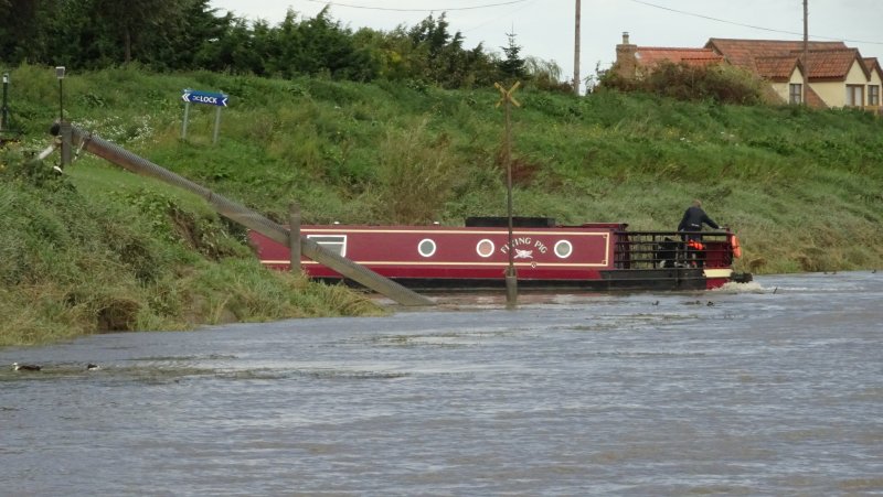
 |
| In this view looking forward you can see Flying Pig ahead of us with the mudbank above the water on their left. |
 |
| Here we are out on the tidal River Ouse with Flying Pig ahead and a cruiser coming in from Kings Lynn heading towards Denver. |
 |
| We slowed down to watch Flying Pig make the turn into Salter's Lode Lock. This is a tricky manoeuvre as you have to turn almost back on yourself with the tide, thankfully not too strong today, coming towards you. Last time we did this we hit the wall behind Flying Pig quite hard and had to repaint the bow afterwards! |
 |
| Once Flying Pig had disappeared into the lock it was our turn. The idea is to turn sharp left and come in alongside the tyres on the wall. This time we didn't hit the wall and in two goes we lined up nicely. Phew!! |
 |
| This is the view looking into the lock. The guillotine is coming down to pen Flying Pig in the lock which can only take one boat at a time. We had to stay against the tyres which was easier than it sounds. |
 |
| This shows Leo holding outside the lock. With the fence on the port side and the tyres on the starboard you get some idea of the narrow hole you have to aim for coming off the tidal river. Weed is floating up the river on the tide and you can just make out the remains of a mudbank here as well. |
From this point it is simple to get into the lock and we were soon through and out on the safety of Well Creek. We headed to Upwell for the night:
 |
| Wells Creek is much narrower and more like a canal than the wide rivers we have been travelling lately. At one point Helen looked across to the fields on the right and asked "are those deer in the field". Out with the binoculars and the zoom on the camera and here they are - three roe deer if we are not mistaken. |
|
 |
| This bear was holding a salmon by the side of Wells Creek. |
 |
| Between Nordelph and Outwell the Creek crosses an aqueduct over the Main Drain which goes to the sea near Kings Lynn. |
 |
| Upwell is a delightful spot with roads and houses either side of the navigable waterway. We celebrated our tide success with a pint in the Five Bells but we did not eat out as we were trying to empty the fridge before going home. |
 |
| The church moorings at Upwell are beautifully looked after by volunteers and even include herbs for the use of passing boaters. The flowers were still very colourful. |
On Monday and Tuesday we decided not to follow the normal route via March through the Middle Levels. Instead we wanted to cruise some new waterways for Leo using the Sixteen Foot and Forty Foot Drains which bypass March.
 |
| We came out of Upwell on Monday passing down through Marmont Priory Lock to the drains which are below sea level. The main route through the Middle Level has signposts: the other waterways there don't have this luxury. This one, seen through the reeds, shows the 'Link Route' to March to the right and our route to the left (it says Three Holes and Sixteen Foot). |
 |
| This is looking back to the link route as we turned left onto Popham's Eau which runs in a dead straight line for two miles. |
 |
| Popham's Eau was deep and weed free and the two miles soon passed to reach Three Holes, the junction seen ahead in the picture. Here the Main Drain goes left and in a few miles reaches the aqueduct we had crossed the previous day, however you are not supposed to navigate that channel. Straight ahead Popham's Eau is marked on our map as continuing to a weir at Nordelph but we could not see any sign of it. Perhaps it is more of a staggered junction than is marked on the map. Anyway we turned right onto the Sixteen Foot Drain. |
 |
| Leo chased some swans down the Sixteen Foot. There was some weed here but it wasn't really a problem. And you can tell it was quite windy too. Why are the drains called 'Sixteen Foot', 'Forty Foot' and so on? Good question. It is not to do with their width as the Sixteen and the Forty are much the same size. A quick search on Google did not give me any answers. |
 |
| Look, a boat!! And we're still chasing swans. In two days this was the only other boat we saw moving on these waters apart from three Middle Level weedcutting boats all stopped for lunch by a bridge. |
 |
| These waterways are straight for miles and miles. There were a lot of swans whose behaviour suggested they don't see many boats. |
 |
| After ten miles with barely a bend the Sixteen Foot meets the Forty Foot and in this picture we have just turned right onto the Forty Foot. The other way (behind Ian's head) is a continuation of the Forty Foot which leads Horseway Lock and then Welches Dam Lock and should give access to the Old Bedford River which is a non-tidal link back to a navigable sluice near Salter's Lode. I've said 'should' give access because for more than 10 years Welches Dam Lock has been out of action. The Environment Agency has so far resisted the pressure from boating groups to mend it. |
 |
| This view is taken looking up the link to Horseway Lock. It looked narrow and weedy. |
 |
| There aren't really any moorings along the Sixteen and the Forty Foot. However we managed to make landfall close to Leonard Child's Bridge for the night. |
 |
| After a boisterous day, the winds died and this was the sunset on Monday night. |
Sadly from here we cruised to our winter mooring and came back home by train on Wednesday. Next year we will start from the Middle Levels. Our choices from here back to the rest of the network are either to return up the River Nene to Northampton or to cross the Wash from Wisbech to Boston. We have a whole winter to think about whether we might attempt that tidal sea crossing or not.
Our final stats for this year's cruising are a total of 829 miles and 471 locks which is less than some of our cruising seasons but more than others. Given that we have had a long spell in the flat lands of East Anglia it is not too surprising that the number of locks is markedly less than usual.
We hope you enjoyed our blog postings for 2018 and will follow our travels in 2019.


No comments:
Post a Comment
If you ask a question in a comment it may be worth knowing that for some reason at present I am unable to reply to a comment unless you choose to let me have your e mail address.