Another rainy day so we are staying put at Shireoaks on the Chesterfield Canal. This update is about our cycle ride on Sunday from Kiveton Park at the top of the connected part of the navigation to Chesterfield. It is about 15 miles or a little further the way we went and we managed OK on our little Bromptons. Unusually for the present spell of weather, we had a dry day at least until we returned to Kiveton Park station for the short hop back to Leo. Though we set out with the idea of following the course of the old canal as closely as possible, in practice, although there is a path of sorts, much of the route is badly overgrown. Where this was the case we followed the Trans Pennine trail on a nearby disused railway.
 |
| This is the bricked up entry to the Norwood Tunnel a few hundred yards along the canal from our mooring by the last winding hole. The tunnel collapsed in 1907 because of coal mining in the area and hasn't been navigable since then. It is this obstruction that means that Leo cannot accompany us on our quest to reach Chesterfield. |
 |
| There is a path over the top of the tunnel, in fact there are several. The plan for restoration of this stretch is to use the first part of the tunnel and then to climb three new locks out onto the summit above the current tunnel. CRT is already responsible for a fishing lake which has been built on top of the tunnel and is designed to be easily converted to a marina when boats arrive here. The land on top of the tunnel (which was about a mile and three-quarters long) was a coal mine but has now been landscaped, trees planted and it is all open to the public. The view above is looking north and west having crossed the hill the tunnel goes under. |
 |
| We found the western portal of the Norwood Tunnel below the footpath we were using. The next section of canal looks fairly navigable to the top of the 13 lock flight at Norwood that used to descend from the summit level. |
 |
| We also found the remains of staircase locks that formed part of the Norwood flight. You can make out the iron strapping on top of the stone where the pivot of the gate was held. We have read that these were some of the first staircase locks in the world. Given the canal opened in 1777 that may well be true. |
 |
| Down below the Norwood Locks the canal is still full of water though a bit overgrown. This picture is taken from a bridge below the flight. We looked at the towpath but it was very overgrown and wet, so we opted instead to divert on cycle paths through Rother Valley Park (another ex coal mining area) and pick up the canal later on. On this route we passed Nethermoor Lake which is planned to be part of the restored canal. This cannot follow its original course through Killamarsh because most of that has been built on. |
 |
| Through Nether Moor village we took to the road to reach the Trans Pennine Trail along the disused Great Central Railway. When building that, the railway company decided that, rather than bridging the winding canal several times, to straighten the canal in a course right next to the railway. It is possible when cycling this stretch to pop up to the canal level. This photo shows the canal and suggests from the vegetation that there is water there somewhere. It is a shame that the Great Central Line was closed. It was straighter faster and more direct than the present East Coast Mainline. Perhaps we would not have had to invent HS2 if we'd kept it open. Still it does make a good cycle track. |
 |
| After about six miles on the Trans Pennine Trail we turned right to pick up the line of the canal west towards Chesterfield. After a zig zag line to cross on old mineral railway we came upon a building site shown here. This is where the Chesterfield Canal Society and Derbyshire are presently working to build a new lock as part of the restoration. |
 |
| Here is the course of the canal, all ready for filling with water, above the lock in the previous picture. Derbyshire County Council presently owns the canal from here into Chesterfield (about five miles) and, with others, has clearly spent a fair bit of money. |
 |
| The navigation restarts at Staveley Town Lock and basin. The lock was finished in 2016 and will connect the wet bit with the dry bit featured above. |
 |
| Above Staveley Town Lock is a huge basin which was used for a trailboat festival in 2012. It will be fitted with pontoons for mooring at a later stage and there are plans to build holiday homes and start-up arts and crafts business units. |
 |
| From Staveley to Chesterfield the canal is properly navigable with five locks as it proceeds up the valley of the River Rother. In this photo we are at Hollingwood Lock where there is a cafe and visitor centre which was quite busy on Sunday. We stopped for excellent ham, cheese and salad rolls and a rather indifferent quiche together with tea. Suitably refreshed we carried on along a well surfaced towpath by the canal. |
 |
| This picture is of the bridge leading into Dixon's Lock. The scenery on this stretch is delightfully rural and the towpath is a popular with walkers. |
 |
| We saw these lovely marsh orchids growing beside the canal. |
 |
| And then, to our surprise, we saw a boat! This was the John Henshall, one of four trip boats operated by the Chesterfield Canal Society to raise funds for more restoration work. |
 |
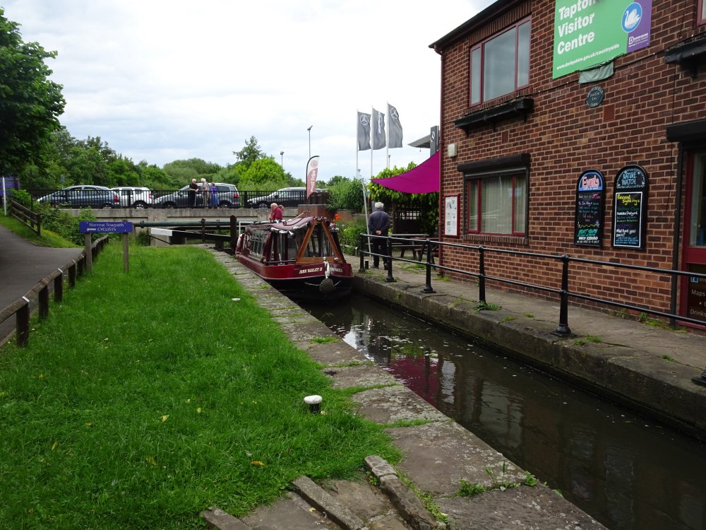
| And so to Tapton Lock, the first on the canal coming out of Chesterfield. Here there is another cafe which just cried out to be sampled, so we had more tea this time with cake. Well we had cycled all the way from Leo. |
 |
| This looks like a lock but isn't. It is a flood gate where the water from a feeder which comes off the River Rother, supplies water into this section of canal. The canal was originally designed to go into the centre of Chesterfield, but this never happened. However part of the restoration plans include a new terminal basin as the centrepiece of the Chesterfield Waterside complex currently under construction near the train station. |
How did we get back? Well by this point we were only half a mile from the station so we returned by train. Dead easy with the folding Bromptons. So that is the story of the rest of the Chesterfield Canal.


No comments:
Post a Comment
If you ask a question in a comment it may be worth knowing that for some reason at present I am unable to reply to a comment unless you choose to let me have your e mail address.